![]()
Buffalo Park and Parkway System - Table of Contents
Buffalo's Park and Parkway System
By Charles BeveridgeA reprint from
Buffalo Architecture: A Guide, by Francis R. Kowsky, et. al. Cambridge: MIT Press
1981
Click on illustrations for larger size -- and additional information
The black and white photographs are reprints from Buffalo Architecture: A Guide

June 5, 2008
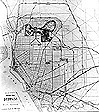
Plan for the Buffalo park system, by Frederick Law Olmsted, 1874
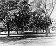
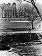
Delaware Park, the Lake and the Casino, circa 1900
Bidwell Parkway, circa 1930
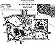
Plan, Cazenovia Park, Olmsted, Olmsted and Eliot, 1896
Cazenovia Park
The Buffalo park and parkway system, designed between 1868 and 1898 by Frederick Law Olmsted and his firm, has a special place in the history of American city planning. The first stage of the system, designed by Olmsted and his partner, Calvert Vaux, and carried out between 1868 and 1876, is particularly important. It was the first of many such systems planned by Olmsted and his successors and was the first demonstration of the form he hoped the expanding American city would take.
The Park
The focus of the Olmsted-Vaux system was 350-acre Delaware Park, called simply "The Park" in the original plans. It was the only public space designed by Olmsted in Buffalo that met his definition of the term "park" - a setting of pastoral scenery extensive enough to provide complete escape from the artificiality and noise of the city. It was also the first park for which Olmsted selected the site. The design that he and Vaux prepared was a classic one, consisting of a 243-acre upland "meadow park" of greensward and scattered trees that was separated by Delaware Avenue (then Delaware Street) from a sheltered "water park" containing a 4.6-acre lake that was formed by damming Scajaquada Creek.
In order to keep the traffic on Delaware Avenue from disturbing he peaceful atmosphere of the park, the designers used a technique they had developed with the sunken transverse roads crossing Central Park. They ran the street below the surface of the park where they could, hid it with thick plantings, and planned the paths and drives in the park so that they crossed over it on a single bridge. Olmsted and Vaux also provided for complete separation of pedestrian and vehicular traffic, so that the danger of collision would not distract visitors from relaxed enjoyment of the scenery. The expressway that now runs through the midst of the park along the course of one of the old carriage drives provides a melancholy contrast with the careful way in which Olmsted and Vaux planned for the movement of traffic.
The 120-acre meadow, now a golf course, is still one of Olmsted's finest open spaces, and the thick stand of trees outside the circuit drive illustrates the way he "planted out" the city beyond. The zoo and its parking lot have expanded to fill an area originally used as a fenced meadow for deer. In the corner of the park near Agassiz Circle there were several abandoned quarries; they were transformed into a series of landscaped pools, following designs made by the Olmsted firm in 1898. They have since been filled, and the only remnant of the 1898 designs is a balustraded bridge, now level with the lawn.
Olmsted and Vaux included two other public grounds in their system: the 58-acre Parade (now Martin Luther King, Jr., Park) and the 32-acre Front. They designed these places for activities that would have been incongruous and distracting to the quiet enjoyment of rural scenery for which alone they created the Park.Front
The Front, on the Erie Canal near its entrance to Lake Erie, served as a formal waterside gateway to the city. It had a carriage concourse, bandstand, playground, and amphitheater. Today expressways and the approaches to the Peace Bridge intrude on the Front and obstruct the view over the lake, but the playground and concourse are more or less intact.
Parade
The Parade, on high ground to the east, provided a view over the city and lake, and contained a parade ground, a grove full of play equipment for children, and a large refectory designed by Calvert Vaux. In 1896 the Olmsted firm redesigned the area, replacing the playground with a picnic grove and introducing, on the site of the parade ground, a series of geometric water features that included a shallow circular basin over five hundred feet in diameter, a rectangular basin for aquatic plants, and a circular fountain area. Today a hockey rink and tennis courts occupy the sites of the two latter features. The science museum, constructed in 1929, occupies much of what was once the spacious entrance of Humboldt Parkway.
Parkways and Avenues
The final element of the plan by Olmsted and Vaux for Buffalo was a series of wide, shaded parkways and streets that connected the Park, Front, and Parade with each other and with the rest of the city. The designers also intended these parkways and streets to serve the need for open space of the neighborhoods through which they passed. As Olmsted described what he hoped to achieve:
Thus, at no great distance from any point of the town, a pleasure ground will have been provided for, suitable for a short stroll, for a playground for children and an airing ground for invalids, and a route of access to the large common park of the whole city, of such a character that most of the steps on the way to it would be taken in the midst of a scene of sylvan beauty, and with the sounds and sights of the ordinary town business, if not wholly shut out, removed to some distance and placed in obscurity. The way itself would thus be more park-like than town-like.
The major street leading to the Park were Delaware Avenue, connecting Niagara Square with Gates Circle, and Richmond Avenue, connecting at Ferry and Symphony circles with streets running to the Front, and joining the parkways at Colonial Circle. The parkway had 200-foot rights of way, along which ran walks and roads and from six to eight rows of trees. On the west side they began at Gates Circle and Colonial Circle and converged at Soldiers Place to form Lincoln Parkway, which ran north to the Park. On the east side, Humboldt Parkway connected the Park with the Parade. Both Lincoln and Humboldt parkways had the special feature devised by Olmsted and Vaux that distinguished their parkways from earlier avenues and boulevards: a central, smoothly paved road for the sole use of private carriages. This carriage drive was flanked on each side by a median with trees, grass, and walks, outside of which were streets for carts and wagons. The four parkways connecting to Delaware Park were the first parkways constructed according to plans made by Olmsted and Vaux. A final link in the Buffalo system was Fillmore Avenue, running south from the Parade.
The Dutch elm disease of recent years has taken a heavy toll on Buffalo's parkways, but current replanting programs promise to restore the West Side parkways and access streets to something like their old attractiveness. On the east, however, Humboldt Parkway has been demolished by Kensington Expressway.
Olmsted grafted his parkway system onto the original radial street plan of Joseph Ellicott, and believed that the combination made Buffalo "the best planned city, as to its streets, public places and grounds, in the United States . . . ... He drew up a map of the city showing these elements, proudly displayed it at the Centennial Exposition in Philadelphia in 1876, and won an honorable mention with it at the Paris Exposition of 1878.
After the end of his partnership with Calvert Vaux in 1872, Olmsted continued to design Buffalo's public spaces. In 1874 he made a new design for Niagara Square, and during the next two years he planned the grounds of the new city and county building (now Old County Hall).
A hiatus of over a decade followed, and when Olmsted returned to Buffalo in 1887 he proposed to create a park and parkway system in South Buffalo that would solve the basic problems of drainage and transportation facing the city in that section. He prepared a design for a 240-acre park on Lake Erie at the city line, consisting primarily of winding waterways between islands to be formed by dredging the marshy site. His plan provided for boating and other activities that stimulated "gayety, liveliness, and a slight spirit of adventure." On the inland side of a railroad embankment next to the park he proposed to have a rifle range that would be flooded in winter for skating. Provision in this place for active sports would, Olmsted hoped, forestall any attempt to intrude them into the quiet scenery of Delaware Park.
The parkway system running out from the proposed south park was to serve as part of a larger scheme for planning the growth of the southern part of the city. The parkways would run through local neighborhoods and then join at a grand viaduct over the broad belt of railroad tracks in the vicinity of the Buffalo River, securing safe and pleasant access to the rest of the city. At the same time the marshy areas on the south side would be drained, and the dike created along the lake for the purpose would make possible a four-mile promenade and carriage drive to the south park and a sheltered canal for access to it by boat.
South Park and Cazenovia ParkThe city fathers rejected Olmsted's proposal as too costly and asked him instead to make designs for two low-lying inland sites that he found "too large for local grounds, too narrow and cut up for parks." His designs for South Park and Cazenovia Park, therefore, were attempts to create passages of scenery in limited spaces while providing at the same time for a variety of recreational needs. His design of 1894 for 155-acre South Park combined pastoral scenery of greensward, groves, and water with an arrangement of 2300 species of trees and shrubs for use as an arboretum. There was also provision for a large conservatory building. Many species still survive, and the waterside scenery, especially on the islands in the lake, give the effect of picturesque richness, variety, and profusion that Olmsted desired. In that respect, South Park provides a telling contrast with the barren shores of the Delaware Park lake.
In his design for 76-acre Cazenovia Park, Olmsted provided for local activities with a playground, carriage concourse, and picnic grove that are still in use. He also sought to secure some of the boating and skating activities that had been the highlight of his first South Park design. He proposed to dam Cazenovia Creek with a removable structure that would permit boating during part of the year and also lower the water level for safe skating in the winter. At the same time he created a passage of water scenery, with islands, inlets, and thickly planted shores. The islands and inlets have now been filled in, and the shallow creek runs a direct course through the park. Since the realization of Olmsted's plan, one hundred and ten acres have been added to the park upstream, primarily for a golf course.The parkway system designed by Olmsted for South Buffalo consists of McKinley Parkway, running from South Park to Heacock Place at the intersection of South Park Avenue and Abbott Road, and connecting at McClellan Circle with the short spur of Red Jacket Parkway that runs to Cazenovia Park. Olmsted's hope for a grand parkway-viaduct connecting the two sections of his system was not realized.
Riverside Park
The last public ground designed in Buffalo by the Olmsted firm was Riverside Park, on the Niagara River in the northwestern part of the city. In 1898, three years after Olmsted's retirement, the firm presented a plan for the 22-acre site. Its features included a fountain, music court, and several buildings, arranged on an axis toward the river and extending on a footbridge over the Erie Canal to a boat landing and pergola on the river. A Y-shaped curvilinear road system separated these formal features from a ball field to the south and a meandering series of paths and shallow, shaded pools to the north. Today only the ball field and the northern strip of roadway survive, along with numerous trees and shrubs in the northern section. No parkway connection to the rest of the system was created, and the park is now separated from the Niagara River by the New York State Thruway.
The park and parkway system that Olmsted and his firm designed for Buffalo exists today partly on the ground and partly in memory and imagination. It provides the observer with a fascinating mixture of the city that is, the city that was, and the city that might have been.