Black Rock -Table of Contents
What Was the 'Black Rock' in Black Rock?
The illustrations and text below are reprinted from The
Picture Book of Earlier Buffalo, Severance,
Frank H., ed. Buffalo Historical Society, Vol. 16, 1912, in a chapter entitled "Early
Black Rock Facts."
Click on illustrations to enlarge
|
|
|
|
|
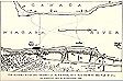
"This rock was blown up and destroyed in 1825 when the
[Erie] canal was built."
Location is roughly where the Peace
Bridge was built.
|
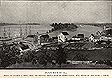
Black Rock in 1825
|
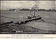
The International Car Ferry, Foot of Porter Avenue.
Operated by the Buffalo & Lake Huron Ry, (now Grand Trunk), 1852-1872. Discontinued
on completion of the International Bridge.
|
Herewith is published for the first time a map of
a section of the Niagara river as it was before the War of 1812 showing the site
of the old ferry at the foot of the Black Rock and many other data of value. Our
engraving is from a sketch made from the original drawing owned by the Buffalo Historical
Society. The original bears this inscription:
"Compiled and drawn from recollection and actual surveys
and information furnished by Captain James Sloan, Lester Brace, Col. William A. Bird
and E.D. Efner, Esq.," by Henry Lovejoy, Surveyor, who was familiar with the
location from 1810 to the present time"
The date of Mr. Lovejoy's drawing was December, 1863. The information relative
to the Canada side was furnished to Mr. Lovejoy by Alexander Douglas of Fort Erie.
On the original drawing are written descriptive notes. These on the engraving are
indicated by numerals, the explanation of which follows:
1. [Far left, just below the middle of the drawing] Starting at the left of
the map on the American side is shown the main traveled road from Black Rock ferry
to Buffalo before and during the War of 1812. It also ran to the eddy under Bird
Island, where vessels discharged and received most of their freight. "The road
was up and along the shore of the river and the beach of the lake to the mouth of
the Big Buffalo creek; up the bank of the Big Buffalo creek to the mouth of the Little
Buffalo creek and up the bank of the Little Buffalo creek to its angle, now [1863]
foot of Pearl street; thence direct to the Terrace at the junction of Main and Exchange
streets."
2. [ To the right of #1] Sand ridge behind which some men took shelter from
the enemy's guns. They were engaged the day before Buffalo was burned in towing vessels
belonging to Joshua Lovejoy up the rapids, when the enemy opened fire upon them.
They were obliged to swing the vessel ashore and retreated behind the sand ridge,
which was full protection. The vessel had several shot through her, but was not disabled.
Her guns were soon brought to bear on the enemy and they were driven off. Dr. Trowbridge
served one of our guns.
3. [to the left of #4] Site of Water-works, 1863.
4. Lester Brace's garden. .
The Black Rock plainly shown on the diagram was a ledge or outcropping of the
native country rock [Ed. Note: Onondaga
limestone], narrowing at its southern end until it disappeared in the
bank. At the northerly end it presented a broad line of cleavage forming a natural
wharf, with a landing for boats somewhat protected from the force of the current.
This rock was blown up and destroyed in 1825 when the [Erie] canal
was built.
Three buildings stood on the rock, as follows:
5. A log house occupied by Orange Dean. Before the war he was employed at the old
ferry. During the war it was occupied by E. D. Efner and from it he furnished clothing
for Swift's regiment.
6. Clark's grocery and boarding-house.
7. Store built by Porter &
Barton, and kept as a tavern during the war until Buffalo was burned, by Orange Dean.
It had several shot through it from the enemy's guns. One, while Dr. Trowbridge was
dressing the wounds of some of
the men who had been engaged in taking the brigs Adams and Caledonia.
8. Lester Brace's barn
9. A building nearly in line of Fort street of later days, was a log house occupied
before the war by Frederick Miller as the ferry-house and tavern. Occupied during
the war by Holden Allen as a tavern until Buffalo was burned. Rebuilt after the war
on the same location by Lester Brace and occupied by him as a tavern and the ferry-house
for a long time.
Before leaving the Black Rock it may be noted that the ferry landing was in the protected
angle at the north end of the ledge. The old ferry-boat was about 32 feet long by
8 feet wide, with two sweeps and a steering oar. The ferry charges were: per man,
2 shillings; man and horse, 4 shillings; one horse wagon, 10 shillings; two horse
wagon, 12 shillings.
The current at this point in the middle of the stream being about 6 to 7 miles an
hour, the old route in crossing was to swing into the current and float down stream
with it, gradually making the Canada shore at about the point near the figure 31
on our map. From that landing the boat made its way up stream close in shore until
opposite the Black Rock, when it again swung out and was carried down stream to about
the present Ferry street, whence it was rowed up to the rock. This route is shown
by the light dotted line on the map.